GeoTagged Newsfeed API (HUB Add-on)

Bringing you all relevant information about the areas you’re interested in, multiple times a day.

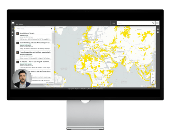
What is the Geotagged newsfeed API?

Say goodbye to trawling countless sites in order to find the energy news and information you need. We automatically assign relevant news articles and press releases from respected sources to each mapped area. This makes it easy to track industry trends and remain up to date with the latest activities and geo-tagged news.

Our geo-tagged news feed comes as an add-on to our MapStand HUB product.

Extensive Information

Extensive Information

Any news on lease rounds, bids, commercial updates, and much more will be included and tagged to specific locations.

Integration

Integration

Easily integrate MapStand’s newsfeed into your own systems using our NewsFeed API.

Provenance

Provenance

All information provided in the newsfeed is linked to the original source with time and date. Have confidence in the data provided.

Customisation

Customisation

All information provided in the newsfeed is linked to the original source with time and date. Have confidence in the data provided.

Frequency

Frequency

Our datasets are automatically updated several times a day from trustworthy sources, so you can rely on the quality and accuracy of our geospatial data.

What is geospatial data?

Geospatial data (also known as spatial data) describes data that is related to a specific location on or near the earth’s surface. The data can refer to objects, events, or any other events with a specific geographic location.

In terms of energy, the location of geospatial data is usually static. However, spatial data can also be dynamic, which is why our datasets are updated regularly (several times a day) to ensure accuracy.

Newsfeed

Geospatial intelligence

Geospatial intelligence and analytics are used to add timings and locations to traditional types of data and build accurate data visualisations. These visualisations may include maps, statistics, graphs, and more.

Visual representations make it easier to interpret and analyse spatial data and make informed business decisions.

Using spatial data and geo-tagged news to make informed business decisions and drive profits

Newsfeed

One of the biggest advantages of geospatial data is that you can use it to make informed business decisions that will drive performance and profits.

Our interactive mapping tool provides a visual representation of data that is user-friendly and easy to analyse, while our geo-tagged news feed helps you track the latest industry activities and events from anywhere.

Take advantage of our extensive datasets and leverage spatial data and geo-tagged news to improve your strategic decisions. This should equate to long-term benefits to your business and bottom line.

Oil and gas
m

Oil & Gas data points

Renewables
m

Power Infrastructure data points

Factory
k

Energy Transition data points

News
k

Geotagged news articles

What our subscribers are saying about MapStand

Testimonials

MapStand gives me near-instant access to critical information as I need it – well info, client blocks, current activity… it’s all at my fingertips without waiting for cumbersome mapping packages to update and load.

VP Project Development
Multi-Client Seismic Company

Quick and easy ability to see what is happening, where it’s happening, and who’s nearby is an invaluable resource in running A&D.

Partner
Oil and Gas Financial Advisors

Ready to get started?

Create an account on our MapStand Community or talk to our experts.